Transportation
Land use and transportation are elements of city design that are completely interconnected with design of transportation systems directly affecting land use and vice versa. The policy of City Plan 2040 to promote efficient, compact development patterns with a reliable, multimodal transportation system is consistent with those of the Virginia Department of Transportation (VDOT).
The City broadly recognizes that great places are accessible; active and engaging; comfortable and safe, and capitalize on community assets. A local street system that is well designed supports walkability, access to transit, and provides gathering spaces. A great place has great streets that help attract people and make the community flourish. VDOT’s emphasis is more pragmatic, yet equally important, in recognizing that a compact development pattern with well-connected streets results in the need to build fewer roads and reduces overall maintenance costs (tax expenditures). While the City and VDOT may look at transportation systems from different perspectives, there is a common goal of creating an efficient and well maintained transportation system that creates great spaces.
This connection between land use patterns and effective transportation systems is so important that state law requires that all localities in Virginia identify, as part of their comprehensive plans, Urban Development Areas with compact development patterns that will be the focus of transportation investment from VDOT. In addition, state code encourages localities to promote transit oriented development, a compact development pattern that focuses more intensive uses in proximity to transit routes. Transit Oriented Development (TOD) supports easier transportation for those without access to cars and provides options for those who chose not to travel by car.
Transportation Efficient Land Use | VDOT
Vibrant mixed use areas within complete neighborhoods offer shorter commutes, ability to use multiple modes of transportation, a critical mass to support local business, and minimizes congestion/need for road expansions. As noted earlier in City Plan 2040, the City of Roanoke is essentially built out. As such, the entire City has been designated as an Urban Development Area. The priorities and actions outlined in the Livable Built Environment theme and Land Use section reinforce transit oriented development patterns
This portion of City Plan 2040 focuses on developing the City’s system of complete streets and how these streets connect to the larger transportation system of the region and beyond, while continuing to make Roanoke a great place to live, work, and play.
Evolution of Transportation Systems
Much like land use patterns, the transportation systems in cities have changed greatly over the last 100 years. If you look closely though, you can see remnants of an older transportation network. In the early 1900’s, people relied on carriages, walking, biking, and public transit (street cars). Because of the reliance on walking for transportation, residents often lived closer to city centers because of the proximity to jobs and commercial needs like markets. Also, the presence of pedestrians in the street was much more prevalent with other modes needing to move around those walking. The opposite of what we see today.
The first wave of growth in Roanoke was due, in part, to the creation of the streetcar with the City’s first streetcar going into service in 1889. This allowed people to live farther away from the city center and still reach essential destinations like downtown and their place of employment. Streets at this point in time were developed to accommodate slow moving traffic. Due to the introduction of the streetcar, cities replaced gravel roads with stone blocks, bricks, or asphalt.
By the 1920s the development pattern that shaped much of Roanoke was in place. Neighborhood centers grew close to streetcar stops with buildings located close to the street for pedestrian customers. Schools were located within the neighborhoods among homes which lined narrow streets with sidewalks. Streets were laid out in a grid pattern providing ease of transportation with multiple ways to move through the community.
By 1925, streetcars were disappearing because of the introduction of buses and the car. This was not unique to Roanoke with 50% of all U.S. cities using buses as their sole means of public transportation by 1937. By 1948, the last streetcar lines, which serviced South Roanoke and Raleigh Court, were completely shut down to make way for the automobile.
Post WWII growth changed much of how we developed our transportation systems. With the post war economic boom also came the baby boom, which meant more people and growing families. This was the beginning of urban sprawl and the “American Dream” notion of a family owning a home in a subdivision with two cars and a dog. Vehicles, which were once viewed as a luxury for the rich quickly became an essential item in every household and allowed the continued sprawl of single family homes into rural areas. As such, our transportation system began to prioritize automobile movement over pedestrian and other modes of travel.
This kind of development of “neighborhoods” is much more of what we see today. More houses were built in suburbs with no sidewalks or multimodal connections to businesses, which meant a greater need for vehicles. This in turn, meant wider and busier roads that accommodate more vehicles traveling farther distances. At the same time street patterns focused more on dead-end streets that funneled all travel to a small number of collector or arterial streets creating issues with congestions and traffic.
During this time, the interstate highways were being built to accommodate the increase in vehicular traffic. The highway system had a number of impacts including making commuting over longer distances feasible, shifting development away from downtowns, shifting freight traffic from rail to truck, and further focusing transportation on cars and taking it away from buses and trains. These shifts had a devastating impact on core urban areas pulling commerce away from neighborhoods where residents could no longer walk to neighborhood stores, leaving neighborhood centers to fall into disrepair and reducing access to needed services for those without cars.
History shows that part of resilient communities is multimodal, pedestrian oriented streets that provides for multiple connections within and between neighborhoods. While we still want an efficient transportation system, it must be effective for all users and contribute, once again, to a strong vibrant community.
Reference Articles:
As transportation systems serve a wide range of needs and cover a wide range of activities (from walking down the street to flying to another country) most transportation planning is done at the regional and state level with input from various federal agencies. The Commonwealth Transportation Board develops Virginia’s multimodal transportation plan, called VTrans which lays out goals, identifies funding priorities, and provides direction to various state agencies and the regional planning agencies. VTrans2040 is the current transportation plan for Virginia.
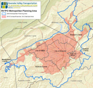
RVTPO Metropolitan Planning Area | RVARC
The Roanoke Valley Transportation Planning Organization (RVTPO) is the regional transportation planning entity that is managed by the Roanoke Valley Alleghany Regional Commission. The RVTPO plans and budgets the use of federal transportation dollars in the Roanoke region in conjunction with state agencies in alignment with VTrans.
The RVTPO is governed by representatives from the various localities in the planning area and is supported by staff from RVARC and other state and federal agencies such as VDOT, the Federal Highway Administration, and the Virginia Department of Rail and Public Transit.
Other partners involved in transportation planning include:
- Federal Aviation Administration
- Federal Transit Administration
- Roanoke Regional Airport Authority
- Greater Roanoke Transit Company
- Roanoke Valley Greenway Commission
At the City level most of the transportation focus is on our streets with coordination with others on rail and air transportation. The City’s Public Works Department manages most transportation related projects with the Transportation Division managing signals and traffic controls, paving, and other traffic management and maintenance items. The Engineering Division designs and implements streetscape projects, such as sidewalk construction, and is responsible for construction and maintenance of bridges. The Departments of Planning Building and Development and Parks and Recreation also play a role in the transportation system by helping to prioritize projects, managing improvements related to private development, and creating off-road transportation connections.
Three primary sources of funding are available for transportation system projects in the City.
State and federal funding is coordinated through the RVTPO as outlined above and includes funds for new streets, significant street improvements, and transit related projects. These projects are funded through a variety of means, most often, the two-year SMART Scale process. SMART Scale funding is competitive at the state level with larger projects largely tied to issues with congestion. The Roanoke Region has limited congestion issues which makes state funding for large transportation projects difficult to obtain. VDOT transportation enhancement and safety improvements funds are frequently used for greenway projects and improvements for traffic signals and crosswalks, among others.
The City also receives an Urban Allocation from VDOT. These funds are primarily used to maintain existing streets (e.g., repave streets, fix potholes or repair sidewalks). Additionally, the City can receive funding for smaller projects through VDOTs cost share program.
The City also allocates local money to fund small-scale complete street projects through the Capital Improvement Program. These projects typically involve constructing sidewalk, small greenway connections, and the like along existing streets.
Transportation Networks
Roanoke’s transportation network is made up of various infrastructure (e.g., streets, highways, railroads, airports) and modes that use that infrastructure, particularly streets (car, transit, pedestrian, etc.). The transportation network functions on various levels based on the need for people to move or goods to be shipped within neighborhoods, within the City, or to other parts of the region, state, country or world. While this plan focuses largely on our local and regional transportation systems, it is important to keep in mind the broader links that are important to our growth.
For a small city, like Roanoke, much of the transportation emphasis is on the street system. City streets provide connections within and between neighborhoods and can be used by pedestrians, bicyclists, transit riders and those using cars. These same streets provide primary transportation connections between our neighboring communities in the valley. Off road connections, such as greenways, can also provide important transportation connections at the local level.
At a regional level, highways become more important, connecting us to our more far flung neighbors in the New River Valley, Franklin, Bedford and Boutetourt Counties, and the Lynchburg area. These same highways provide connections farther across the state and the country.
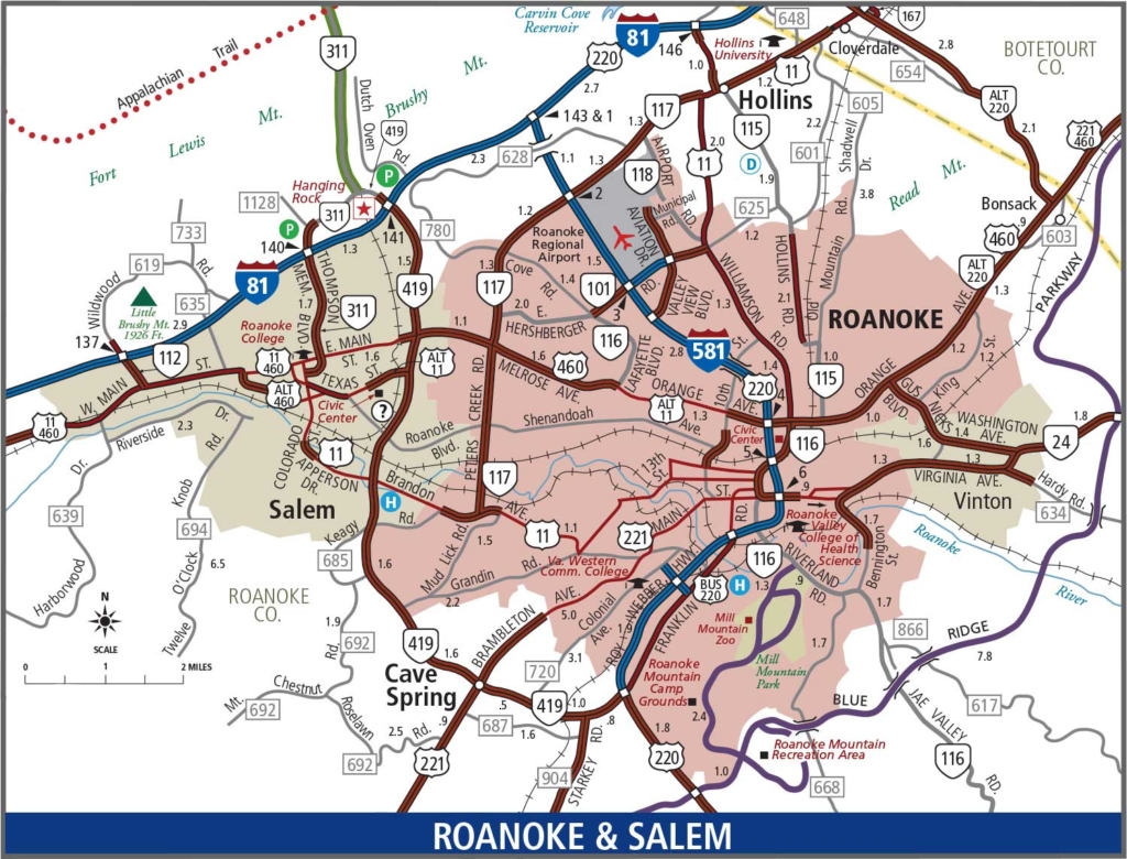
Roanoke and Salem Transportation Map | VDOT
Our rail and air connections become important for travel and shipping over long distances with connection outside the region.
A well connected multimodal transportation system is critical for creating accessible and vibrant neighborhoods and providing the critical regional, national and international links that are critical for a connected city and vibrant economy.
The primary transportation system within Roanoke, connecting us to our immediate neighbors, is our street system. All City streets must be complete streets that provide for safe, effective, and attractive connections for all users.
This street network provides multimodal connections within and between the City’s neighborhoods. This street network also provides the framework for commuting within the valley and for the local transit system, Valley Metro. The City Council adopted a Complete Streets Policy that recognizes the importance of good street design and requires that complete street elements be included as part of City infrastructure projects. The City’s Street Design Guidelines provide details for creating complete streets and establishes the hierarchy of City streets as shown:
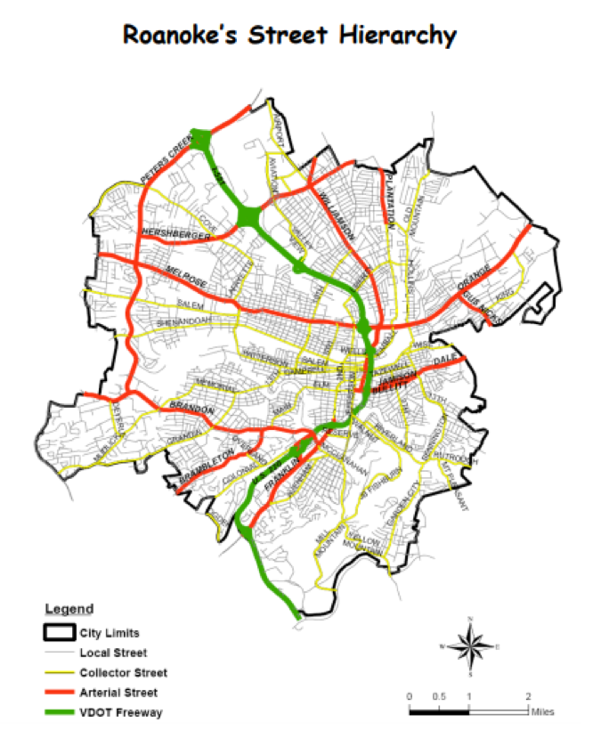
Locals – Provide access to residences, businesses, and other destinations that provide goods, services, or activities. Local streets constitute the majority of streets in the City and generally have a low traffic volume and low speeds.
Collectors – Provide a combination of access (ability to get to a specific place) and mobility (ability to move between areas of the City). Collector streets typically have a moderate level of traffic that travels at moderate speeds.
Arterials – Provide mobility (ability to move within the city and to surrounding areas) with typically higher volumes of traffic and speed than other streets.
VDOT Freeway (Limited Access Highway) – I-581 and the Roy Webber expressway (Route 220) provide high speed travel to motor vehicles with access only at specific interchanges. These highways are operated and maintained by VDOT, not the City.
The primary needs for our local street system is to maintain and improve complete streets where they exist and to adapt and retrofit the remaining streets to incorporate complete street elements so all streets are safe for pedestrians, bicyclists, and transit riders. When new development occurs, it should make use of the existing street system and when street extensions are required those extensions should provide additional connections to reinforce a grid network.
As high levels of congestion during peak travel periods is generally not an issue, projects focused solely on capacity, such as adding lanes, are generally not needed. Projects along collector and arterial streets may be appropriate to increase efficiency by improving signals, etc. in conjunction with complete street projects. Widening arterial streets is disruptive (requiring acquisition of private property and long-term construction projects) and often results in attracting more traffic to the street, thus exacerbating the problem. Furthermore, complete street projects can improve efficiency at a fraction of the cost of adding lanes and have the benefit of enhancing neighborhood character.
Transit coverage is provided within the Cities of Roanoke and Salem, the Town of Vinton and the Tanglewood area of Roanoke County by the Valley Metro bus system (operated by the Great Roanoke Transit Company). Frequent comments from the City Plan 2040 process call for expanded transit service with expanding hours of service, routes, and providing service seven days a week. RADAR provides paratransit and senior transportation services in the City, and CORTRAN provides similar service in Roanoke County. Public comments also addressed these paratransit and senior transportation services.
Many Roanoke residents rely on transit for access to jobs and other destinations. Even within the City, the Valley Metro Bus service has limited hours and does not operate on Sundays, which creates a gap for those who rely on transit or would otherwise like to use it as an alternative to a car. Expansion of the Valley Metro system or development of other transportation options is critical to improving mobility within the City and throughout the region.
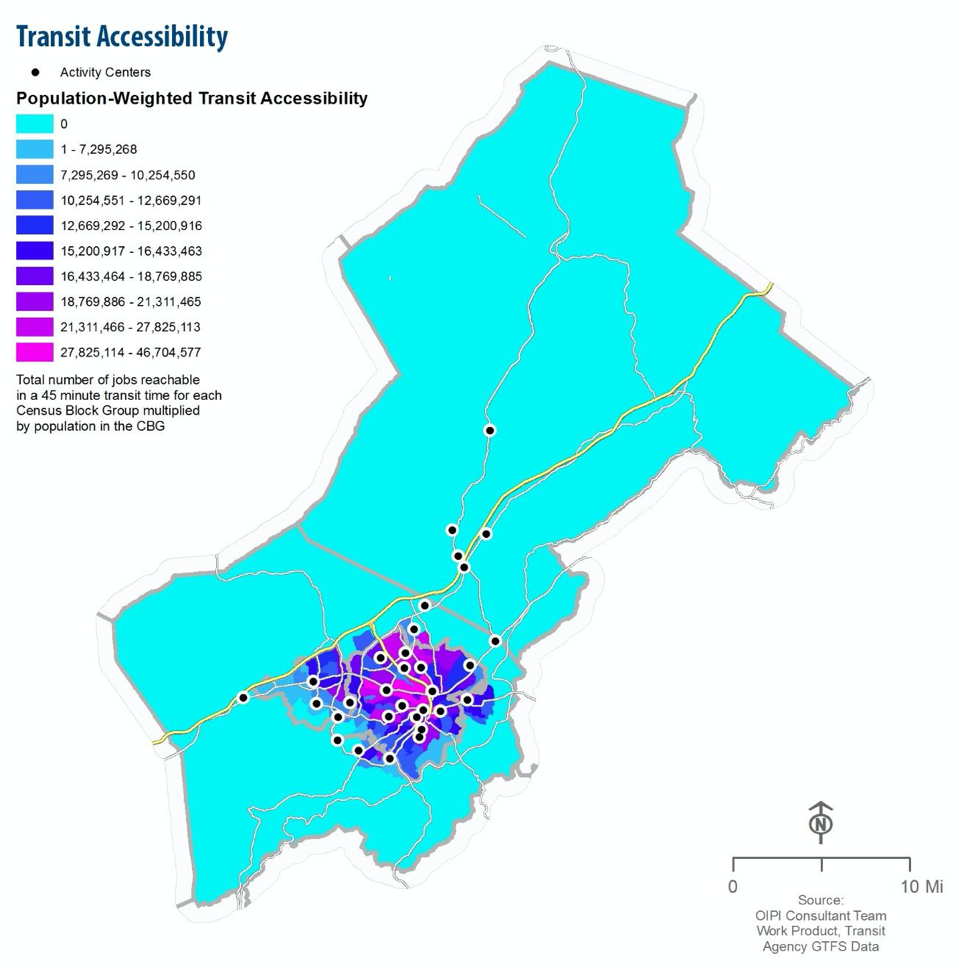
On a regional level, the issue of transit access is clearly reflected in VDOT and RVTPO plans. In particular, the regional transportation plans show that there is a complete lack of access to activity centers outside of the City. The map below shows the limitations of the current public transportation system. Regional industrial parks in Roanoke, Franklin, and Boutetourt Counties cannot be reached by transit, effectively precluding residents from seeking potentially high-paying employment opportunities. One bright spot of regional transit is the Smartway bus service operated by Valley Metro, which connects Roanoke to Blacksburg and Virginia Tech.
Working with partners through the RVTPO to expand regional transit is important to provide access to jobs for those without access to cars and also to provide options to those looking for an alternative to a car.
Connecting the Region and Beyond
The regional transportation network connects the valley with other localities in our region and also provides links to other parts of the state and country that are critical for commerce. In addition to the local streets and transit system, the broader transportation system consists of limited access highways, air travel, and rail.
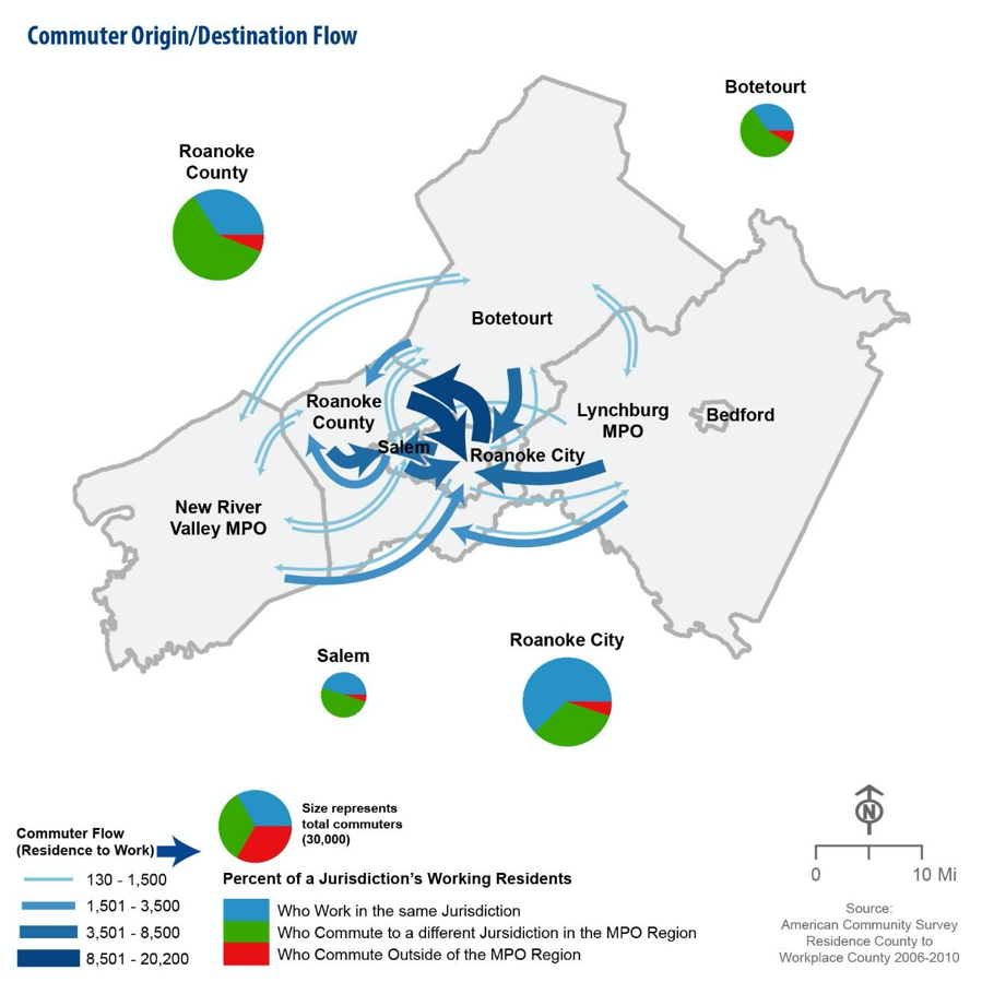
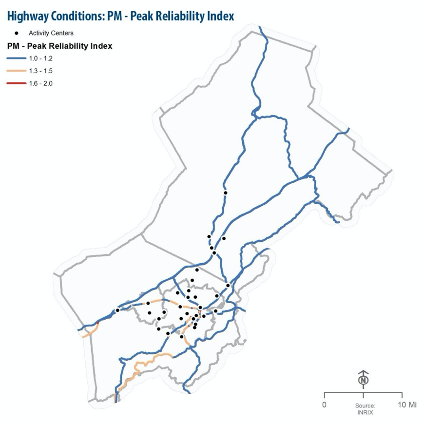
A large volume of commuters travel to and from the City each day as shown. Despite the high levels of commuting between the City and neighboring localities, the level of traffic congestion in Roanoke is low, at least by state-wide standards. High congestion is generally present during peak rushes only along the US Route 460 corridor (Melrose and Orange Avenues), the US Route 220 expressway, and portions of Brambleton Avenue and Williamson Road. This indicates that major road building is not required to handle current levels of commuting and that improving transit options and improving efficiency can likely handle any increases in demand for the foreseeable future.
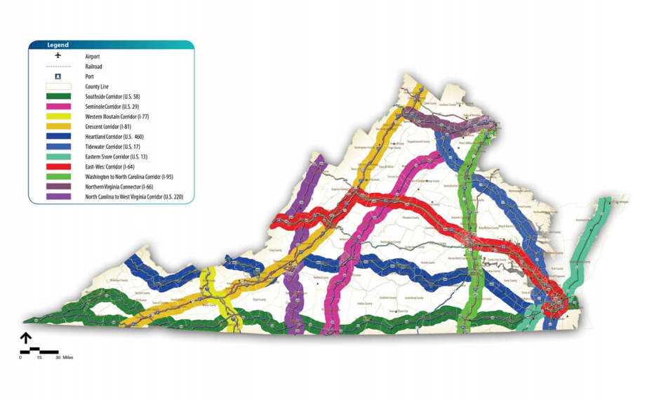
Corridors of Statewide Significance (CoSS) are identified in Vtrans2040 as highways vital to our regional transportation system due to their primary function for connecting regional activity centers, statewide travel, and even interstate travel. There are three CoSSs that run through the City of Roanoke:
- North Carolina to West Virginia Corridor, including Route 220/I-581 runs North to South from the southern tier of New York through North Carolina
- Heartland Corridor mainly consists of Route 460 and runs East to West from Norfolk to Frankfurt, KY
- Crescent Corridor generally defined by I-81 but also consists of Route 11 and portions of Route 460 and runs along the Appalachian Mountains
CoSS | VTRANS
Within the City of Roanoke it is important to recognize these corridors still serve local needs and offer options for multiple modes of transportation. Some of these corridors, like I-581, are not good candidates for multimodal improvements. However, there are many sections, like Route 11 (Brandon, Grandin, Campbell, Williamson), Route 460 (Melrose and Orange), and Route 220 (Franklin Road) that should allow for improved multimodal use. There is a constant balance between meeting the needs of regional commerce while maintaining streets that are safe and comfortable for biking and pedestrian use.
Long distance travel options are also provided by bus, train, and air. Virginia Breeze bus service is offered between Blacksburg and Washington, DC and regular Greyhound bus service is provided through Roanoke. Rail travel returned to Roanoke in 2017 with the extension of Amtrak’s Northeast Regional line to provide service to Washington, DC and further to Boston.
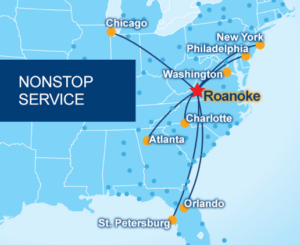
The Roanoke–Blacksburg Regional Airport provides connections to large cities and major airline hubs in the eastern US, providing direct connections to major metros and opportunity for easy connections to the remainder of the country or to international destinations.
At the regional level, the City will work with RVTPO partners for a careful balance of CoSS improvements that allows for efficient transportation in the region, expands transit options, and retains local street character within the City. Roanoke will work with RVTPO and other partners to expand bus, train, and air service to destinations outside the region.
Transportation of goods and material is crucial for Roanoke and the region. The top three industries in the Roanoke Region for output is wholesale trade, retail trade, and manufacturing which makes up almost 50% of the region’s output. All three of these rely heavily on freight transportation.
The City of Roanoke has easily accessible options for freight transportation as shown below. Major highways such as in Interstate 81, and US Routes 460, and 220 provide the primary routes for most freight shipments to and from the area (the VDOT Corridors of Statewide Significance).
Reinforcing land use patterns that encourages manufacturing or distribution operations with significant transportation needs in relatively close proximity to these corridors is important to minimize truck traffic on local City streets.
While Roanoke developed as a railroad town, most of Norfolk Southern’s shop operations have relocated. Roanoke is still at the center of a large rail network with connections to cities and ports across the eastern half of the United States. The ability to transport bulk materials across long distances, especially access to ports may prove a valuable asset for the right business.
The Roanoke-Blacksburg Regional Airport is an important air freight terminal for the region with facilities operated by both Federal Express and UPS as well as air freight services provided by airlines operating from the airport. In 2015, nearly 13,000 tons of air freight was handled. Air freight is an important component of a healthy business climate as air freight is fast, reliable, and highly secure. Air cargo accounts for less than 1% of all material shipped but accounts for 35% of the value of shipped material (worldwide). The Roanoke Regional Airport Commission’s future plans include a significant expansion of its air cargo capacity.
With easy and accessible freight movement comes great opportunity for existing businesses to expand and new businesses to start or relocate in the region. As the City grows and evolves over the next 20 years we must assess demand for freight shipments, changes in how freight is shipped and adapt to those changes. We must ensure that freight movement remains accessible to businesses, that a connected freight network is provided (trucks, trains, and air), and that businesses that rely on freight transit are appropriately located to minimize impact on local streets from a safety and complete streets perspective.
Current Projects and Construction
The VDOT Six-Year Improvement Program identified projects that are funded for planning or construction activity. There are no major road projects under construction or slated for funding within the City in the current six-year improvement program. There are a number of projects related to pedestrian improvements, signal improvements, greenways, and drainage improvements.
At the regional level, there are several needs for the Corridors of Statewide Significance identified in the VTrans corridor plans. Generally, issues within the Roanoke region were focused on limited to minor congestion, segments of roads with a higher number of crashes, and limited rail and transit options between surrounding cities. Our regional network has identified five areas of needs: corridor reliability/congestion, network connectivity, transportation demand management, modal choice, and walkable/bikeable places. As such, the policies and actions set forth should aim to address the needs identified in the VTrans Needs Assessment Report for the Roanoke Region.
Priority: Great Streets Supporting Great Places
Priority: Regional Transportation Networks
Priority: Transportation Projects