

Urban Design
Background
The City of Roanoke is a vibrant urban center with strong neighborhoods set amongst the spectacular beauty of Virginia’s Blue Ridge. The overall goal of City Plan 2040 is to further transform Roanoke into an attractive place for people of all ages, backgrounds, and income levels to live, work, shop, and play. The form of development within our community impacts each citizen on a daily basis; therefore, how that development pattern shapes our community as it grows is important for everyone.
Good design is not optional. The quality of the physical environment – attractive buildings, parks, open space, and streets – has a direct impact on Roanoke’s economy, the sustainability of its neighborhoods, and the successful stewardship of its unique natural and cultural resources. The community expects a high level of excellence in building design, streetscapes, pedestrian amenities, preservation of special places, and enhancement of community distinctiveness.
In the history of the City of Roanoke, there have been periods of growth and decline and rebirth. Chartered in 1884, the City of Roanoke followed previous settlement in the Roanoke Valley that built upon the location along transportation routes; first the Great Warrior Path used by Native Americans, then the Great Wagon Road “locally known as the Carolina Road” used by settlers in the Colonial period, and then by railroads that sought to transport materials, particularly coal, in the 1800’s.
When the area was chosen as the junction for the Shenandoah Valley and Norfolk and Western railroad, Roanoke was formed and grew with the jobs created by the railroad and supporting industry. As pictured in the annexation map , Roanoke grew quickly through the early years of its existence as a city and annexed surrounding property based on the growth of the City.
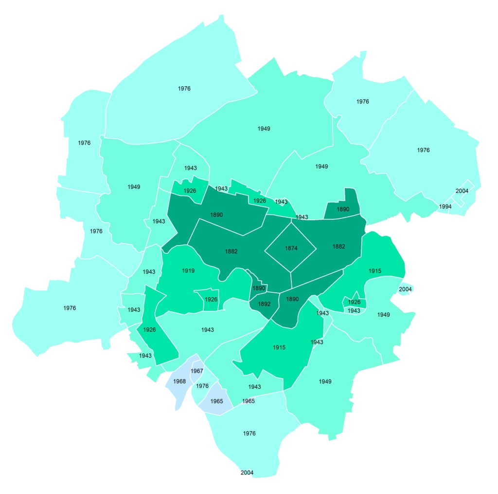
Annexations over the history of the city’s incorporation
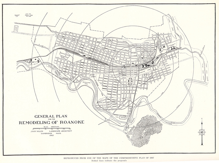
The City of Roanoke is unique in that it has a long history of planning for its future in a comprehensive manner to best serve present and future generations. In 1907, when the City of Roanoke had grown to a population of 30,000 people, a local group of women hired John Nolen to create a report on how the City of Roanoke could be best developed. The report, with accompanying plans, was broad in scope and recommended changes throughout the City including: the street network, major streets and streetscapes; provision for parks, parkways (known today as greenways), and playgrounds throughout the City; the placement of buildings within certain areas; and regional planning. Although the report and plan was not a regulatory document, many items within this first comprehensive planning effort were carried out over time.
Today, Roanoke continues to be a city whose citizens desire to grow in the best manner possible to serve both existing and future generations.
Roanoke in the 1928 comprehensive plan
Today, the City of Roanoke has an area of just over 42 square miles, most of which have been built out. Within this compact area, the community is made up of a series of neighborhoods: a strong downtown, complete neighborhoods with neighborhood centers, neighborhoods without neighborhood centers, commercial and industrial centers, and parks and natural areas linked by a transportation network that is also linked to the surrounding region.
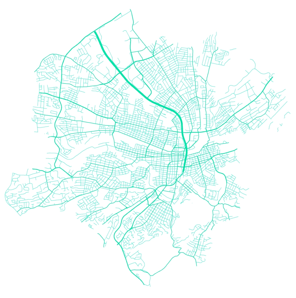
Patterns created by the street system
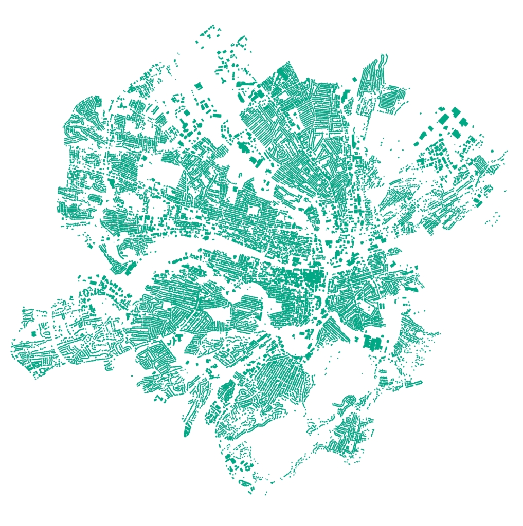
Patterns created by building footprints
The defined Character Districts will guide how we achieve the continued transformation of our existing development pattern within the city into one where all citizens can live, learn, work, play, and prosper.
Character Districts
A transect is a system for categorizing the character of areas along a straight path. A transect of the existing development within the City of Roanoke from the least developed areas at the edges to the most developed area at the center reveals multiple areas of distinctive development patterns. These distinctive development patterns result from varying aspects of four elements: residential areas, centers, public spaces, and corridors. The character, form, and the transition from one element to another within these distinctive development pattern areas are defined as character districts.
The City of Roanoke has four general categories of character districts:
Downtown
Urban Neighborhoods
Suburban Neighborhoods
Natural Area
The distinctive development patterns found within each character district should continue to play a role in the future development of each area. While the overall City is reflected in these basic categories in the community character map, each neighborhood will be further examined during the neighborhood planning process.
During the neighborhood planning process, City staff and community members will determine which policy should be applied to individual areas from the character district category: maintain, enhance, or create community character. Neighborhood planning areas may have multiple individual areas governed by these different policies. Where the existing character of the area is set and works well for the community, the policies can recommend the character be maintained or enhanced. Where the desired future character differs from the current character, the policy can recommend creating the new community character. Each neighborhood character policy will provide further guidance on the form and character of development within the community.
Character District: Downtown
Downtown is characterized by a pronounced skyline, pedestrian friendly streets, and a mixture of retail, office, residential, and light industrial uses. Generally, uses are small scale, high intensity, and diverse. The Downtown pattern extends into the surrounding Belmont, Gainsboro, and Old Southwest neighborhoods. Downtown streets form an interconnected grid and accommodate both vehicular and pedestrian users. Buildings are located adjacent to the sidewalk and often adjoin each other. Parking is generally concentrated in parking structures or is located to the side or rear of principal buildings.
Characteristics:
- Compact development pattern
- Wide variety of land uses
- Full or nearly full lot coverage
- Shallow and consistent building setbacks
- Minimal or no space between buildings
- Additional access to lots from alleys
- Very high level of connectivity (pedestrian, bicycle, vehicular) with sidewalks, bikeways, and mass transit
- Compact block structure
- Two-way streets with on-street parking and street trees
- Landscaping is typically formal with simple geometry that relates to the surrounding buildings and a restrained palette of plants
Residential Areas
Residential dwellings are one of many uses throughout the downtown area in tall mixed-use buildings, multistory apartment buildings, and low-rise townhouses/rowhouses.
Centers
Downtown is the center of the region with an integration of uses throughout the area instead of particularly segregated centers. Office and commercial uses occupy the dense downtown core in buildings that sit at the street edge forming a strong street wall. The buildings cover large portions of the lot. At the periphery of the downtown area, buildings transition in scale, massing, and detail to reflect aspects of the surrounding urban neighborhood areas.
Institutional uses are interspersed throughout downtown. The buildings often have a deeper setback with public gathering spaces between the building and the street and a larger lot.
Industrial uses exist around the periphery of downtown.
Public Open Space
Public open spaces are formally developed with simple geometric designs, a sense of enclosure, and a restrained plant palette. They range from the regional draw of Elmwood Park, to the open plaza at Market Square, to localized pocket parks and rooftop plazas.
Corridors
A compact block structure and complete street grid provide multiple options for transit: pedestrian mobility, biking, vehicular, and mass transit. Parking is generally concentrated in parking structures or is located to the side or rear of principal buildings.
Design principles:
- Downtown should have a recognizable skyline; tall buildings and maximum site development should be permitted. Buildings should be set close to the street with ground floor facades that emphasize pedestrian activity.
- Buildings should be designed to accommodate a mixture of uses. Downtown’s historic character should be preserved and used to guide new development with the assistance of the Architectural Review Board guidelines.
- Access to and circulation within the downtown should be efficient, convenient, and attractive. Streets should be designed to accommodate multiple modes of traffic: pedestrian, bicycles, transit, automobiles. All streets with sufficient width should be two-way. Streets with higher traffic volumes (for example, Campbell Avenue) should function and have the feel of other downtown streets.
- On-street parking should be used for shoppers and short-term visitors. Longer-term parking should be provided in parking structures or to the side or rear of principal buildings. Creation of surface parking lots should be avoided; existing surface parking should eventually be eliminated.
- Existing industrial centers should introduce a mixture of complementary residential and commercial uses, maximize site development with buildings developed along street frontage, address the street with entrances, etc. All activity should occur within wholly enclosed buildings with loading and outdoor activity subordinate to the principal building and attractively screened. Parking and loading areas should be attractively landscaped.
Character District: Urban Neighborhoods
These neighborhoods developed between the 1890s and 1940s adjacent to downtown and as the streetcar system expanded outward. Urban neighborhoods often feature residential housing, churches, neighborhood schools, and small neighborhood commercial centers in a compact development pattern linked by a grid of narrow tree-lined streets and alleys. Neighborhoods are often connected by commercial corridors or streets with higher traffic levels that bridge the rivers, railroad, and topography that create breaks in the grid transportation system.
Characteristics:
- Small to medium-sized lots (typically 3,000 to 7,000 square feet)
- Mixed housing types
- Moderate lot coverage in residential areas and high lot coverage in neighborhood centers
- Shallow and consistent building setbacks
- Minimal space between buildings
- Lots have additional access via alleys
- Highly connected street systems where pedestrian, bicycle, and vehicular traffic are well-accommodated
- Small block lengths ranging from 300 to 600 feet. Two-way streets with on-street parking and street trees
- Landscaping is typically formal
- Neighborhood centers at busier intersections/corridors with higher lot coverage/close setbacks
Residential Areas
This area is predominately single family with accessory dwelling units and two-family dwellings. Small apartment buildings that are similar scale to surrounding houses are sparsely distributed throughout the area among the single-family dwellings; more intensive housing types are located near neighborhood centers and along corridors.
In urban neighborhoods, it is not uncommon to find mixed-use areas with a variety of housing types and lower-intensity commercial uses of similar building massing and design as the surrounding residential dwelling units as they are often residential units converted to office or other commercial use. These mixed-use areas tend to occur in transition areas between residential areas and centers or other more intensive districts.
Centers
Neighborhood scaled commercial and mixed-use centers are often found at intersections near busier streets and are situated so they can be accessed by most of the neighborhood by a 5-10 minute walk. Buildings often form a denser pattern with zero setbacks and higher lot coverage. The scale of buildings complements the density and housing that surrounds them.
Institutional uses may be present within the centers or may be interspersed throughout an urban neighborhood. When interspersed, there is often a deeper setback or larger lot.
Industrial centers are typically located in areas near the Roanoke River or railroad lines. They are often in close proximity to residential areas.
Public Open Space
Shared open space such as parks and plazas are provided as extended living spaces for residents.
Corridors
A compact block structure and filled-in street grid provide multiple options for mobility: walking, biking, driving, and transit. Due to the river, creeks, railroad, and topography, the grid is not continuous and some streets that provide connections between neighborhoods have a higher volume of use. The corridors with a higher volume of use (such as Williamson Road NW, 9th Street SE, Brandon Avenue SW, and Melrose Ave NW) have enhanced pedestrian, bicycle, and transit accommodations.
Design principles:
- Proposed development (infill development, alterations, renovations, and additions) should create or enhance a distinctive character that relates well to the surrounding community through setbacks, scale, massing, primary entrances facing streets, ample window openings, durable materials, and architectural detailing.
- Residential buildings should have consistent setbacks from the street.
- Two-family and multifamily buildings should be of similar scale to the residential housing that surrounds it; while such housing near the neighborhood centers and corridors may be larger in scale.
- Institutional buildings may be on larger parcels and setback further from the streets with civic spaces connecting such building to the street.
- Neighborhood center buildings should be set close to the street and have street facing entrances and windows that enhance pedestrian activity.
- Corridor improvements within urban neighborhoods should focus on streetscape enhancements with greater pedestrian, bicycle, and mass transit amenities.
- Existing industrial centers should introduce a mixture of complementary residential and commercial uses, maximize site development with buildings developed along street frontage, address the street with entrances, etc. All loading and outdoor activity should be subordinate to the principal building and attractively screened. Parking and loading areas should be attractively landscaped.
- Outdoor storage and activity should be attractively shielded from street and surrounding properties
- Avoid excessive lighting
- Vehicular entrances to property should be defined
- Parking and loading areas should have trees along street frontages.
- Well-designed historic buildings should be preserved and should be used to inform new development.
- Neighborhood schools and commercial nodes should be preserved.
- All streets should have sidewalks and should be lined with trees between the sidewalk and the street. On-street parking should be encouraged rather than having each lot contain its own parking. Where off-street parking is provided, it should be located to the rear of the lot; driveways and garages should be located to the side or rear of buildings.
- Streetscapes in neighborhood centers should promote pedestrian activity through broad sidewalks and public gathering spaces.
- Streetscapes around and within commercial and mixed-use centers should have shared parking and reduced curb cuts.
Character District: Suburban Neighborhoods
Suburban neighborhoods are characterized by larger lots (greater than 7,000 square feet), a variety of housing sizes and styles, deep front yard setbacks, wide streets, and prominent driveways and garages. These neighborhoods developed after World War II as dependency on the automobile increased.
Characteristics:
- Medium to large-sized lots (greater than 7,000 square feet)
- Mixture of residential housing types – predominately single-family housing, with segregated pods of multifamily buildings.
- Low lot coverage in residential areas and moderate lot coverage in neighborhood centers
- A mixture of moderate and consistent or deep and varied building setbacks depending on the neighborhood
- Moderate to wide spacing between buildings
- Lots typically accessed only from local streets or neighborhood collector streets
- Low to moderate connectivity of street system with emphasis on vehicular connectivity and little emphasis on pedestrian, bicycle and mass transit
- Long block lengths with dead ends and/or curvilinear streets
- Parking is typically provided on each lot. Front yards and building façades are often dominated by vehicular access (driveways, carports, and garage doors).
- Landscaping can be formal or informal
Residential Areas
This area is predominately single family dwellings. Other housing types are often located near commercial corridors in separated nodes.
Centers
Neighborhood scaled commercial and mixed-use centers are within a 5-10 minute drive of the surrounding neighborhoods with limited access to mass transit. More often large commercial centers are strips located along larger thoroughfares outside residential areas.
Institutional uses may be present within the centers or may be interspersed throughout an urban neighborhood. When interspersed, there is often a deeper setback or larger lot.
Industrial centers (such as Statesman Industrial Park, Aerial Way, Salem Turnpike/Shenandoah Corridor west of 24th Street, etc.) have buildings and activity mainly in developed industrial parks and defined corridors. Industrial buildings are often large, setback from the street, with large parking and/or loading areas. Streets in industrial parks and corridors are designed for truck and other vehicular traffic, often with little accommodation for pedestrians, bicyclists or transit users.
Open Space
Parks and public open spaces are few within suburban neighborhoods; as with access to commercial goods and services, getting to a public recreation facility requires driving.
Corridors
Corridors in suburban neighborhoods tend to emphasize vehicular mobility with multiple travel lanes, high speeds, turn lanes, and little pedestrian, bicycle and transit accommodation.
Along many corridors, low-intensity strip development exists with large spaces between buildings and large amounts of parking. Large-scale commercial centers are often situated along or located at intersections of these corridors.
Design principles:
- New development should incorporate urban neighborhood principles rather than replicate suburban principles.
- Commercial centers should incorporate complementary residential uses, parcel development along street frontages, public open space for community gathering, reduced surface parking areas with landscaping throughout, well defined driveways (street-like feel), and pedestrian/bike access through the center.
- Commercial center connections into the surrounding communities should be strengthened to include pedestrian and bike accommodations.
- Industrial centers should maximize site development with buildings developed along street frontage, address the street with entrances, etc. All loading and outdoor activity should be subordinate to the principal building and attractively screened. Parking and loading areas should be attractively landscaped.
- Outdoor storage and activity should be attractively shielded from street and surrounding properties
- Avoid excessive lighting
- Vehicular entrances to property should be defined
- Parking and loading areas should have trees along street frontages.
- Overall street improvements within suburban neighborhoods should focus on greater vehicular connection, pedestrian amenities, and reduction of pavement width.
- Corridor improvements within suburban neighborhoods should focus on streetscape enhancements with greater pedestrian, bicycle, and mass transit amenities.
Character District: Natural Areas
These areas are mostly publicly controlled spaces or privately owned land permanently protected by conservation easements. Some are maintained as open space with grass cover but most acreage is forested in a more-or-less natural state. These natural areas often contain environmentally sensitive features like waterways, flood plains, scenic viewsheds, or steep slopes.
Characteristics:
- Expanses of forest or grassland
- Mostly undeveloped
- Land uses limited to recreation or agriculture.
- Low connectivity
- What few buildings and structures exist are limited to civic uses
- Access through natural areas are via multiple use paths, trail, and fire roads (paved and unpaved)
- Informal landscaping
Design principles:
- The proximity of adjoining Character Districts will influence the design of the edges of this area and the access to the area.
- Development should complement the natural context.
- Many acres of grass turf areas in parks are unused and should be converted to forest.
- Landscaping is informal and new plantings use native species in a manner that compliments the natural environment.
- Artificial lighting is very limited and focused toward the localized need for it.
- Pedestrian and bicycle connectivity should be high.
- Parking areas should be limited in number, small, and should blend into the natural environment. Generally parking surfaces should incorporate permeable paving materials.
